|
Could the Roman Port on Wirral have a name?
Meols was
one of the most important settlements in the north west. It has existed for thousands of years and became an important port to the Romans.
It pre-dated the more famous Roman outpost of Chester and was vital for
supporting the land forces as they swept through England. That there was
a Roman port at the top of the Wirral is in do doubt, but knowing it's
name is a different matter.
Portus Setantiorum was a Roman port situated in the north west of England,
specifically on the west coast somewhere between Anglesey and Morecambe
Bay.
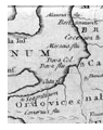 A
contentious and somewhat discredited Roman map was 'discovered' by Charles
Bertram in 1755 but was later determined to be a fake. This map could
be interpreted as showing the missing Roman port situated on the Wirral
peninsula right near its tip.
A
contentious and somewhat discredited Roman map was 'discovered' by Charles
Bertram in 1755 but was later determined to be a fake. This map could
be interpreted as showing the missing Roman port situated on the Wirral
peninsula right near its tip.
Whilst now generally disregarded, the Bertram map labels Roman places
which were apparently unknown at the time of its alleged forgery but that
have since been discovered to be correct.
Portus Setantiorum
is generally thought to have been situated at Fleetwood which is at the
tip of a peninsula, with the River Wyre on the East. There is a known
fort at nearby Kirkham associated with a road running coastwards, and
this road terminates at modern-day Fleetwood.
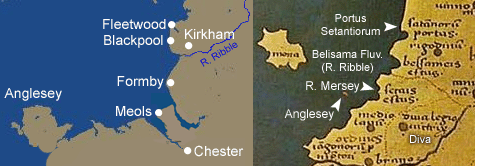 The
main reason for locating the 'lost' port here is based on the map of Ptolemy
on which a label for the River Ribble appears south of the label for the
the 'portus'. The map is not open to a great deal of interpretation because
the order in which places appear should theoretically be correct, however
there are certain things to consider, such as the fact that the label
Belisama Aest (River Riblbe) and Seteia Aest (River Mersey) are separated
by a road, whilst neither label is clearly pointing to a specific waterway.
There are other issues to consider, such as the fact that Anglesey is
so insignificant as to nearly disappear, whilst Deva (Chester) is miles
from the river Dee. It is not the case that there is no confidence in
the Ptolemic geography, but for the purposes of this wild theory we will
would have to believe that the order in which locations are listed could
be flawed.
The
main reason for locating the 'lost' port here is based on the map of Ptolemy
on which a label for the River Ribble appears south of the label for the
the 'portus'. The map is not open to a great deal of interpretation because
the order in which places appear should theoretically be correct, however
there are certain things to consider, such as the fact that the label
Belisama Aest (River Riblbe) and Seteia Aest (River Mersey) are separated
by a road, whilst neither label is clearly pointing to a specific waterway.
There are other issues to consider, such as the fact that Anglesey is
so insignificant as to nearly disappear, whilst Deva (Chester) is miles
from the river Dee. It is not the case that there is no confidence in
the Ptolemic geography, but for the purposes of this wild theory we will
would have to believe that the order in which locations are listed could
be flawed.
One other argument in favour of the Fleetwood placement is that the area is thought to have been within the domain of the Setantii tribe, a sub-group of the Brigantes, and it is they who lend their name to the Port of Setantorium. However with evidence showing that the tribe's influence extended all the way to the Mersey, and that that river itsself was called the Setia, it would not be totally unreasonable to think the port could be situated on the Wirral peninsula instead.
The site of Meols on the Wirral has geographical factors in its favour. If we look to the coast here, shelter is afforded between the promontory of Dove Point and Hilbre Island and here lies the deep water of the so-called 'Hoyle Lake' which gives modern day Hoylake its name.
Further out to sea is the Hoyle Bank which offers protection to the natural harbour and it is understandable how this area has seen continual use for such an long period, including sustained Saxon, Norse and Medieval occupation. There is even thought to be a clinker vessel buried under the car park of the Railway Inn.
Another pub not far away which also underlines the naval significance of the area is The Kings Gap, so called because William of Orange set sail for Ireland with his fleet from these shores.
We know that the western tip of the Wirral was connected to the fort of Chester by Roman a road which will have utilised a pre-existing iron age trackway for much of its length. With Chester being so important during Agricola's campaigns in the north, it is perhaps significant to note the suggestion that Portus Setantiorum was first heard of in Agricola's survey which preceeded the campaign.
If the Roman fleet was used to supply and support the land forces, and if Agricola's land forces were based at Chester, then Meols is the logical place for the port.
Finally, there are known Roman naval bases at Holyhead and Lancaster, and Meols lies neatly between the two.
Sadly there is a lack of archaeological evidence to support this theory and it remains somewhat fanciful conjecture, but given the important nature of Meols in Roman history, it would be nice to give it a name.
Based on
work by P. France and J. Emmett.