|
RIGORE VALI AELI"
Bowness, Drumburgh-by-Sands, Stanwix, Castlesteads
along the line of the Aelian frontier
 Julius
Caesar, before he became leader, made two expeditions to the island of
Britain in 55 BC and 54 BC, the first of which was a failure, and the
second was to begin to coerce the local tribal kings to pay tribute to
Rome. There followed a period of diplomatic understanding between the
Empire and the Island and trade was established with the Romans through
the turn of the Millennium.
Julius
Caesar, before he became leader, made two expeditions to the island of
Britain in 55 BC and 54 BC, the first of which was a failure, and the
second was to begin to coerce the local tribal kings to pay tribute to
Rome. There followed a period of diplomatic understanding between the
Empire and the Island and trade was established with the Romans through
the turn of the Millennium.
In 43AD Aulus Plautius took several legions and invaded the south coast,
winning several battles with the aid of elephants and, pushing up past
the Thames to finally take the capital Camulodunum (modern-day Colchester,
and site of the only known Roman
Circus in Britain).
The revolt in 60-61AD led by the famous Boudica destroyed the Roman colony
at the capital, caused the Romans a severe setback, and very nearly convinced
Nero that Britain was more trouble that it was worth. In the year following
the administrative turmoil of 69AD the Romans reasserted their hold on
the Island, conquering all the way up to the north of Scotland, however
around 105AD the Scottish tribes proved too much for the Romans, forcing
them south and leaving a wake of burnt forts.
At the beginning of Hadrian's reign a new uprising in Scotland was the
last straw for the visiting Emperor and when he toured Britannia in 122AD,
he instructed the building of a mightly barrier to draw a line under the
acceptable limits of Roman expansion. It was the first ever Roman statement
of the end to the expansion of the Empire.
 The
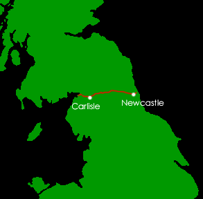
result was what we now call "Hadrian's Wall": A 73.5 mile (80
Roman mile) long military fortification which stretches from coast to
coast across England. It's primary purpose was built to prevent military
incursions from the north, but also would allow limited regulated trade
with friendly tribes. It was a physical mark for the most northerly extremes
of Roman territory and exploited naturally high ridges across the breadth
of the country to maintain a strategic advantage against any attackers.
The
result was what we now call "Hadrian's Wall": A 73.5 mile (80
Roman mile) long military fortification which stretches from coast to
coast across England. It's primary purpose was built to prevent military
incursions from the north, but also would allow limited regulated trade
with friendly tribes. It was a physical mark for the most northerly extremes
of Roman territory and exploited naturally high ridges across the breadth
of the country to maintain a strategic advantage against any attackers.
 The
wall took about eight years to build, starting in the east in modern-day
Newcastle (later extended to a part of the city called Wallsend), and
terminating on the west coast, on the shores of the Solway Firth. Eighty
Milecastle forts, each a Roman mile apart would run the length of the
barrier with several dozen troops in each. The wall was designed to run
at an ambitious 10 feet wide and about 20 feet high but varied depending
on the available materials in the area, with some sections being built
largely from turf, and the planned thickness of the wall diminishing early
in contruction.
The
wall took about eight years to build, starting in the east in modern-day
Newcastle (later extended to a part of the city called Wallsend), and
terminating on the west coast, on the shores of the Solway Firth. Eighty
Milecastle forts, each a Roman mile apart would run the length of the
barrier with several dozen troops in each. The wall was designed to run
at an ambitious 10 feet wide and about 20 feet high but varied depending
on the available materials in the area, with some sections being built
largely from turf, and the planned thickness of the wall diminishing early
in contruction.
 As
development progressed it was decided that in addition to the Milecastles
and turrets, more than a dozen large forts holding up to 1,000 troops
would be added, giving a total occupation on the wall of roughly 9,000
throughout.
As
development progressed it was decided that in addition to the Milecastles
and turrets, more than a dozen large forts holding up to 1,000 troops
would be added, giving a total occupation on the wall of roughly 9,000
throughout.
After Hadrian died, a new ambitious line of fortification was set up further
north: the Antonine Wall named after the Emperor who planned it. However
he was unable to conquer the tribes beyond, and the Hadrian's Wall was
once again the main line of defence in 164AD.
The wall suffered serious assaults from the Picts in 180 and 196 and sections
had to be reconstructed but beyond that into the third century AD the
wall was peaceful and the occuping troops steadily integrated into the
local families.
As the third century wore on, Rome relaxed its grip on Britain as various
invaders such as the Saxons combined with decline across the Empire to
make the prospect of maintaining this extreme outpost less attractive.
By 410AD the Romans had withdrawn their military and the country was left
to fend for itself. With the inter-marrying of local tribes and Romans,
there were enough military families remaining who called Britain their
home to allow the wall to be garrisoned for a period well into the fifth
century.
The
Roman Forts along Hadrian's Wall - Banna (Birdoswald)
Banna was one of the 16 forts along Hadrian's Wall and is positioned at
the western end. Today there is a visitors' centre on the former farm
site which is called Birdoswald. It is unique in being the only place
on the length of the wall where occupation can be demonstrated during
the Sub-Roman era. One portion of the site has been excavated, showing
the granaries whilst the rest of the site has been excavated and re-filled,
or is awaiting excavation.
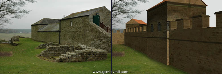
The picture above left was taken at Birdoswald (Banna) in October 2007
and shows the north west corner of the fort. The image above right is
a computer-generated model of the fort in position, with the repositioned
wall on the left of the picture, running off to the west.
The
wall itself was originally built from turf and the fort was a later addition
and positioned so that the wall ran through its east and west gatehouses.
It was manned from AD 112 AD to 400 and habitation continued until about
500AD. The internal buildings consisted of central headquarters, granaries,
barracks and exercise area. 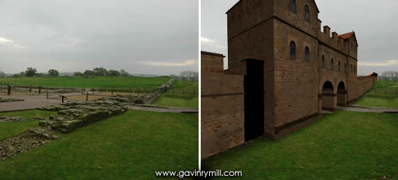 The
granaries which are exposed today were later replaced by timber halls
which are now represented by large wooden posts. In the image on the right,
the camera is looking south, down the length of the west wall and in the
centre of the picture is the west gatehouse. Walking through the gatehouse
these granaries are on the right.
The
granaries which are exposed today were later replaced by timber halls
which are now represented by large wooden posts. In the image on the right,
the camera is looking south, down the length of the west wall and in the
centre of the picture is the west gatehouse. Walking through the gatehouse
these granaries are on the right.
There were also settlements either side of the fort showing how these
military structures became centres of the community.
 The
original turf wall which ajoined the east-west gatehouses was replaced
by a stone wall, but it was moved to align with the north wall of the
fort. No other site is known to demonstrate this kind of repositioning
allowing comparison of the two types of wall.
The
original turf wall which ajoined the east-west gatehouses was replaced
by a stone wall, but it was moved to align with the north wall of the
fort. No other site is known to demonstrate this kind of repositioning
allowing comparison of the two types of wall.
To the east of the fort lies Milecastle 49 which contains the remains
of pre-Roman buildings, and beyond it is the remnants of a bridge which
allowed the wall to cross the River Irthing without interuption.
Click
here to read about the Time Team dig of Banna.
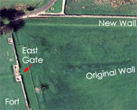
The Wall from The Air
Modern technology allows us now to do some amazing "armchair archaeology"
as this picture on the left demonstrates. It is an image taken from the
superb Google Earth which you can download for free here.
The route of Hadrian's Wall is clear on the satellite photographs and
if you follow its route across the country you will also see that the
images show up various in different states of exposure. The image above
left is a prime example as it clearly shows the line of the original turf
will as a dark shadow running towards the East Gate. 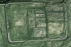 On
the West side of the fort it is not immediately clear but a little further
away from the fort the dark line of the turf wall becomes extremely clear
and can be followed west along its old course until it converges with
the modern stone wall.
On
the West side of the fort it is not immediately clear but a little further
away from the fort the dark line of the turf wall becomes extremely clear
and can be followed west along its old course until it converges with
the modern stone wall.
 Google Earth affords many opportunities to explore the course of Hadrian's
Wall quickly and scout around various places which are hard to access
from a public highway. It is by no means a substitute for getting up there
and walking around the Roman sites, but it is a fascinating adventure
in itself. It also allows a visitor to one of the forts to put it in context
if they don't intend to walk any the wall's length. Sites like Vercovicium
(modern day Housesteads) pictured above right are as much a revelation
from the air as they are impressive on the ground.
Google Earth affords many opportunities to explore the course of Hadrian's
Wall quickly and scout around various places which are hard to access
from a public highway. It is by no means a substitute for getting up there
and walking around the Roman sites, but it is a fascinating adventure
in itself. It also allows a visitor to one of the forts to put it in context
if they don't intend to walk any the wall's length. Sites like Vercovicium
(modern day Housesteads) pictured above right are as much a revelation
from the air as they are impressive on the ground.
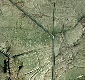
When exploring from the air the hidden chunks of history become visible.
These may be difficult to derive excitement from at ground level, and
are sometimes not even visible on-site, but on the aerial photography
are burried structures still to yield their secrets. The image above left
shows a selection of building outlines not far west of Housestead, partly
aligned to a north-running road which would have lead towards the wall
in Roman times and still forms part of the path of the modern-day road.
Following Hadrian's Wall east on Google Earth will take you right into
the centre of Newcastle and if you look carefully you will see sections
of the wall only a feet long which crop up alongside A186, West Road,
reaching the place where construction began.
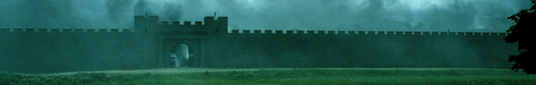
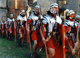
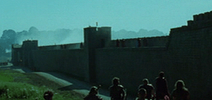
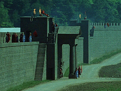
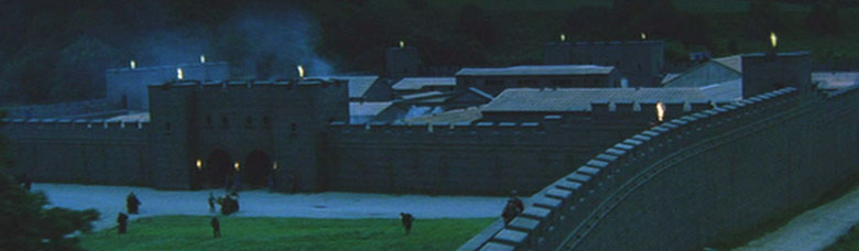
The Portrayal of Hadrian's Wall in Fiction
The images at the top of this page which show a complete and impressive
Hadrian's Wall are taken from the film King Arthur. The film,
whilst entertaining fiction, is nevertheless a muddled mess of historical
facts, inaccurate dates, and incorrect events. The basis of the film is
that King Arthur of legend was in fact a Roman soldier from the far flung
Sarmatia who was drafted thousands of miles across Europe to the border
of Scotland. Whilst it is true that the Romans enlisted the help of various
tribes, there is no logic to the movement of this collection of Sarmatian
men from one end of the Empire to the other.
The film suggests that the Pope weilds power but this incorrect because
although the Roman Empire was undoubtedly Christian by this period, all
directives were purely Imperial. The film also makes out that Britain
is still a country of occupied natives under Roman rule but the film is
set in 467 AD, so there have been four hundred years - thats twenty generations
- since the first Romans arrived, and the Christian population of Britain
would have considered themselves Romans. When we talk about a Roman "withdrawal"
from Britain, it is purely from a military point of view, not a cultural
one, and sub-Roman Britain existed as a Romanised culture for nearly a
century until further invasions. With this in mind, it is also incorrect
to suggest that the Christian Romans (such as in the family Arthur is
sent to rescue) would be spending their time torturing and sacrificing
the local pagans, because most of Roman occupied Britain was Christian,
not pagan.
Putting the historical issues to one side, the film is worth a look, if
only for the magnificent (if possibly rather overblown) recreation of
Hadrian's wall, which was 1km long set built in Ireland.